I have mulled over whether to post this due to the sensitive nature but have decided to go ahead. This blog is here to chronical parts of my outdoor experiences in life.

In October 2009 on an otherwise normal day that I should drive the hour or two to visit my parents in North Wales litle did I expect to witness something incredibly sad. I always make the short walk to the beach to catch up with some sea and shore birds while mum cooks tea. When I got to the beach I scanned up and down the large flat sandy expanse and noticed what I though at first was a small boat tilted on the sand.... it was around half a mile away. I looked again and realised it wasnt a boat. The shape and size made my initial thoughts of a Dolphin but as I hurried towards it I soon realised this was indeed alot larger.

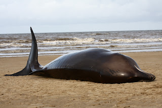
I was the only person in the area and was confronted with this:


I rang the police who put me through to the Coast Guard 


The tide was coming in so the Whale must have been beached for a few hours, she still felt warm and soft to the touch. No visible signs of injury, only a few marks where birds had started to feed.


I spent a few further minutes completely on my own and in abit of shock.... I took images just to ensure it was real... someone in the world maybe glad of this information and images


A passing fishing boat stopped to check it out, this image gives an idea of the tail size.


I had been here for an hour and notice how the tide had come right up to the stranded whale. I knew the tide wouldnt shift it but it would make work difficult for the arriving Coast Gaurd.

Indeed the Coast Guard (with an entourage of local kids) arrived just as the tide lapped up to the Whale.


A post mortem was eventualy carried out and the following information released:

The northern bottlenose whale was a sub-adult female, 2-3 tonnes, 6.21 metres long and died from dehydration and Liver failure designated SW2009/330.
Location of stranding was Grid Ref: SJ 093 850 Gronant Sands, Prestatyn, Denbighshire, North Wales.

The carcass was dragged inshore across the sands to SJ 093 840 which took it into the next county, Flintshire where the post-mortem examination took place.

Following this, further corresponce took place between myself and Cestation scientists in Sri Lanka who keep records and investigations of all Cestation Stranding throughout the world

Media information regarding the stranded
from The Sunday Times:
"Scientists say man-made noise equipment, including anti-seal sonar devices used in fish farms, is driving deep-water animals such as whales to shore, where they die.
A northern bottlenose whale was washed up dead on a beach in Prestatyn, North Wales, on Saturday morning, the tenth of the species to become trapped or stranded on British shores this year.
Scientists are blaming not just military sonar, but a large range of man-made noises that they fear are driving the normally deep-water animals to shore."


Crowden Horseshoe - taking in 1951 Meteor Crashsite on Black Hill

Just over an hour transfer time to the starting point at Crowden YH and what looked like a cloudy start to the walk was in prospect....  however it turned out to be quite a contrast to how the day actualy panned out.

Peter, John and myself (Gary missing his first walk for a while) set off from the Youth Hostel carpark and headed up through the gorge between Bareholme Moss and Hey Moss. We followed Crowden Little Brook as far as sheepfolds... the prefered route chosen was to stay as close to the brook as possible which made for some pioneering footsteps rather than the nearby but well worn path at Hey Edge.


Crowden Little Brook


towards Sheepfolds


Looking back towards the distant Bleaklow


Sliddens moss in the foreground with Holme Moss transmitting station on the horizon


Here we took our co-ordinates and were able to navigate to the crash site of 2 Meteor jets that crashed in 1951

"At 9:15am on Thursday 12th April 1951 a flight of four Meteor jet aircraft took off from RAF Linton-on-Ouse near York for a training flight. Flying the lead pair were Flight Lieutenant David Merryweather Leach (WA791) and Flying Officer Tony Hauxwell (VZ518). The flight was to climb to around 30,000ft where the two pairs would carry out attacks on each other.
The weather forecast for the day was for complete cloud cover from 1,500ft to 20,000ft, but on reaching 30,000ft the four aircraft were still in thick cloud and radioed Linton on Ouse to inform them that the flight would be returning home. All four aircraft turned back towards Linton-on-Ouse, though after having descended back through 20,000ft Flt Lt Leach reported he could see what he thought was Leeds through a break in the cloud and he and F/O Hauxwell were going to proceed down. The second pair could not see through the cloud and not being entirely sure of their position radioed their intention to remain at 20,000ft. After some 5 minutes the lead pilot of the second pair, Flying Officer Leslie Hayward, attempted to contact Flt Lt Leach with no success. RAF Northern Radar at Lindholme near Doncaster attempted to contact the pair again with no success.
Following this a search was mounted with wreckage being spotted later in the day with a ground team reaching the scene the following afternoon. The two aircraft had continued to descend through cloud and without ever breaking out of the bottom of the overcast cloud and had flown into the top of the moor in formation. The marks left by the two aircraft are still clearly visible as is wreckage of the 2 aircraft strewn over 1\4 mile os Sliddens Moss"


impact scars


memorial cross


its incredibly sobering to see this!

From here and for the next 90 minutes we encountered somewhat of a slog though the waterlogged peat and extremley rugged landscape....  however the next stop was the Trig point at Black Hill and a well earned pit stop at Soldiers Lump


Trig Point - Black Hill


The return journey would take us back down the opposite side of Bareholme Moss and following
Crowden Great Brook


looking towards Crowden and the YH just showing at the far end of the valley


Bfb on Laddow Rocks


looking back at Laddow


the descent


Rakes Rocks


back to base


Thanks to Pete for contributing some of the images after my batteries let me down at the Trig Point

The walk was around 9.5 miles long and took in some incredible landscape and stunning scenery.... and just to make sure we got it all......the sun shone all day!


A once yearly pilgrimage to mid Wales is always eargerly anticipated..... this years spectacle was no less rewarding than previous years....  a gentle reminder to my self  "Make the trip in the snowy winter for full effect of rufous reds against snowy white backdrops......"

Gigrin farm is now an official Red Kite rehabilitation and feeding centre. 400+ Kites may travel from upto 50 miles away for an afternoon top up of prime beef.... throw in some Buzzards, Ravens and Carrion Crows and the spectacle unfolds during any afternoon if you ever choose to visit this remarkable place.

A quick google of Gigrin Farm will give you all the details you need, but basically from a single pair of visiting Kites chancing their luck for scraps on a sheep farm to todays incredible daily numbers is quite an acheivement.

On Saturday around 200-250 birds came to feed... the following images are an out-take of a wonderful afternoons entertainment with a true aerial magician

Majestic


Climb...


Squadren Leader


the hunter


Low flying


mid air refuel


Soar


aerial attack

Ladybower, Derwent Edge and Win Hill:

The forecast of rain was prominant from the off but we had agreed that at least a stretch of the legs would be a good idea before the inevitable heavy rain moved in..... so John, Gary, Peter and myself met at Ladybower Reservoir for our 13 mile circular ramble taking in the lovely high plataued moorlands of Derwent edge with a finishing peak of Win Hill.

Climbing Lead Hill
and looking down on Ladybower Reservoir with Win Hill opposite and Lose Hill far right


On the way up Lead Hill


Ladybower and the sullen skies


nearing the moorland of Derwent Edge


The 3 likely lads at the start of Derwent Edge
John, Gary, Peter


a rugged landscape... the Hurkling Stones


across the edge


Wheel Stones


Gritstone boulders, shaped by the elements


there is a face in there somewhere


where the Red Grouse call.... aswell as the Golden Plover, Skylark, Meadow Pipit and the beautiful Mountain Hares 

Leaving White Tor


and heading for the Salt Cellars


Gary making them look Big....


Gary making them look small ....


the peat landscape is very delicate in places and due to the traffic errosion slabs of stone have been helicoptered in to make pathways to save the areas most at risk


Dovestone Tor


even the sheep are taking shelter for the inevitable change in weather


trig point at Back Tor


yet another rocky outcrop high up on the moorlands


and yes another Trig Point is bagged by the Incoherent Ramblers


and just to make sure that I get in on the act... Bfb!


from Back Tor looking down to Lost Lad


Looking back up to Back Tor


Weather watch.... the clouds role in, however
it does make for a wonderful view.


the rain drove hard for the next 2 hours so a slow descent through the rolling counrtyside


and back down towards the reservoirs


while Win hill collected the rain clouds.... we figured that it could wait to be climbed on another day


Popular Posts

Blogger templates

Blogger news

Blogroll